The sea, in numbers
Three weeks on station and the buoy has quietly built something we've never had for this beach: an actual record. Here's what it says, including the day we made four weather models argue and let her settle it.
21 days, five words
Every quarter of an hour she files a reading, and every reading lands in one of our five words. Stack them up by day and you get the season at a glance: a run of glassy mornings, Clean as the workhorse word, a few Lively afternoons, and (until this week) almost no Choppy at all.
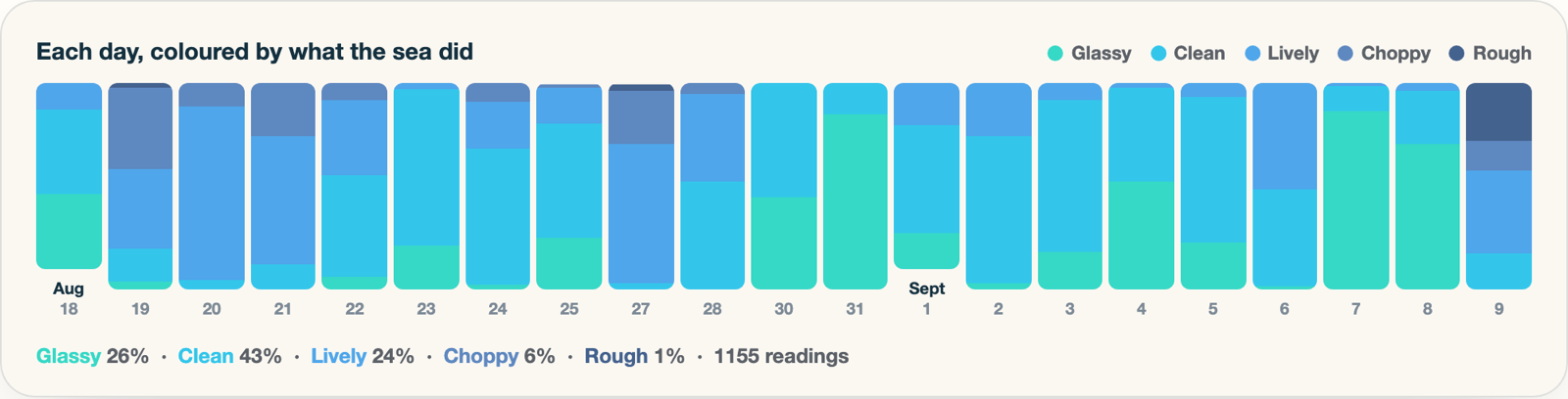
The tally so far: roughly a quarter of all readings Glassy, nearly half Clean, a quarter Lively, and a thin slice of Choppy. Rough barely registers. If you were wondering whether this coast earns its reputation for gentle water: yes, measurably.
The temperature rollercoaster
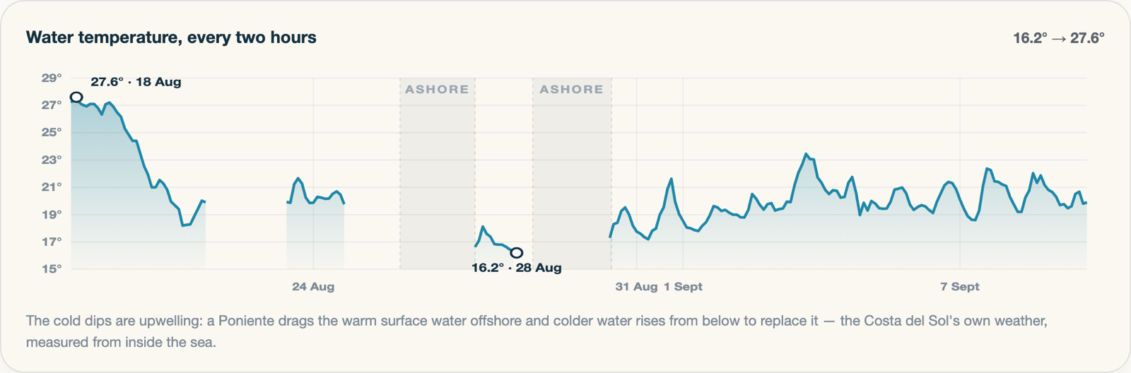
The water chart is the one that surprises people. Mid August we were swimming in 27.6 degrees. Ten days later: 16.2. That's an 11-degree crash, and nothing to do with weather fronts or seasons. It's upwelling: a strong Poniente (the westerly that funnels out of the Strait) drags the warm surface layer offshore, and cold deep water rises up to replace it. The sea gets colder on a sunny week. Locals know the feeling well; now there's a chart of it.
The bet: four models, one judge
Last Saturday I noticed my forecast and Windy disagreed hard about Wednesday. So we pulled the raw predictions from four big weather models for our exact mooring and wrote them down. Three of them (ECMWF, GFS, Meteo-France) called a Poniente: a westerly filling in through Wednesday afternoon, 10 knots and building. One (ICON, the model our app happened to be using for wind) called a gentle 5-knot sea breeze from the south, dying at dusk.
You can't referee that argument from a sofa. But we have a referee bolted to the seabed.
Wednesday afternoon the sea went from Lively to properly Rough: waves building to 0.96 m, short and steep, the biggest single wave 1.45 m from trough to crest. And the direction? Averaged across the whole blow, the waves came from 247 degrees. ECMWF had said 248. One degree off. ICON's gentle southerly was nowhere.
So the app's wind source is getting a rethink, and we're keeping score from now on: every model gets marked against the buoy, spot by spot, day by day. Over a season that becomes something genuinely rare: we won't have to guess which forecast to trust here, we'll know.
Why this matters
None of these numbers came from a model. Every one is a measurement from a small yellow instrument that was getting thrown around in the water while it took them. Forecasts are opinions about the future. This page is what actually happened. The longer she floats, the more valuable that gets.